
Stammbach topographic map
Interactive map
Click on the map to display elevation.
About this map
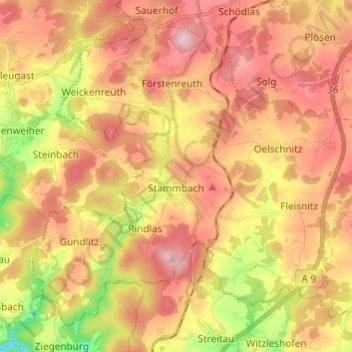
Name: Stammbach topographic map, elevation, terrain.
Location: Stammbach, Landkreis Hof, Bayern, Deutschland (50.11525 11.64225 50.18106 11.76335)
Average elevation: 564 m
Minimum elevation: 419 m
Maximum elevation: 669 m
Other topographic maps
Click on a map to view its topography, its elevation and its terrain.
Köditz
Deutschland > Bayern > Landkreis Hof
Köditz, Landkreis Hof, Bayern, 95189, Deutschland
Average elevation: 543 m
Wurlitz
Deutschland > Bayern > Landkreis Hof > Rehau
Wurlitz, Rehau, Landkreis Hof, Bayern, 95111, Deutschland
Average elevation: 544 m