
Lac Miroir topographic map
Interactive map
Click on the map to display elevation.
About this map
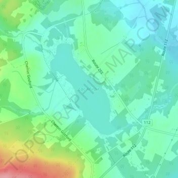
Name: Lac Miroir topographic map, elevation, terrain.
Average elevation: 234 m
Minimum elevation: 204 m
Maximum elevation: 320 m
Other topographic maps
Click on a map to view its topography, its elevation and its terrain.
Rivière Saint-François
Canada > Québec > Le Haut-Saint-François > Dudswell > Bishopton
Rivière Saint-François, Bishopton, Dudswell, Le Haut-Saint-François, Estrie, Québec, Canada
Average elevation: 292 m
Lac d'Argent
Canada > Québec > Le Haut-Saint-François > Dudswell > Marbleton
Lac d'Argent, Marbleton, Dudswell, Le Haut-Saint-François, Estrie, Québec, Canada
Average elevation: 299 m