
Make a donation
Gear up for your next adventure:
As an Amazon Associate, this site earns from qualifying purchases at no extra cost to you.
Perinthalmanna topographic map
Click on the map to display elevation.
Make a donation
Gear up for your next adventure:
As an Amazon Associate, this site earns from qualifying purchases at no extra cost to you.
About this map
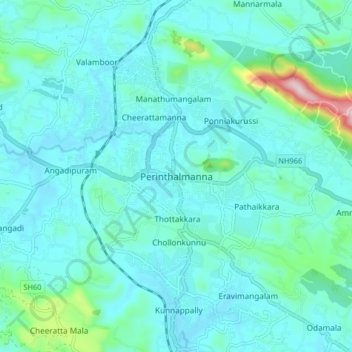
Name: Perinthalmanna topographic map, elevation, terrain.
Location: Perinthalmanna, Malappuram, Kerala, 679322, India (10.93568 76.18626 11.01568 76.26626)
Average elevation: 76 m
Minimum elevation: 23 m
Maximum elevation: 413 m
Make a donation
Gear up for your next adventure:
As an Amazon Associate, this site earns from qualifying purchases at no extra cost to you.
Other topographic maps
Click on a map to view its topography, its elevation and its terrain.
Kolaparamba
India > Kerala > Perinthalmanna > Kollithodi SC Colony > Pattiyiparamb SC colony
Average elevation: 62 m
Temple Pond, Bhagavathi Padam, Angadippuram
India > Kerala > Perinthalmanna > Angadipuram
Average elevation: 45 m
Make a donation
Gear up for your next adventure:
As an Amazon Associate, this site earns from qualifying purchases at no extra cost to you.