
Make a donation
Gear up for your next adventure:
As an Amazon Associate, this site earns from qualifying purchases at no extra cost to you.
Brandnertal topographic map
Click on the map to display elevation.
Make a donation
Gear up for your next adventure:
As an Amazon Associate, this site earns from qualifying purchases at no extra cost to you.
Brandnertal
The Brandnertal is located in the southern part of Vorarlberg, in the far west of Austria. Adjacent to Switzerland, the Principality of Liechtenstein and Germany. In the immediate vicinity of the city of Bludenz starts the Brandnertal. From Bürs the valley rises, via Bürserberg to Brand, which is at an altitude of more than 1,000 m. The Schesaplana and the Lünersee, which lies at the foot of the highest peak of the Rätikon, form the end of the valley.
Make a donation
Gear up for your next adventure:
As an Amazon Associate, this site earns from qualifying purchases at no extra cost to you.
About this map
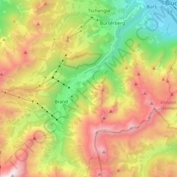
Name: Brandnertal topographic map, elevation, terrain.
Location: Brandnertal, Brand, Bezirk Bludenz, Vorarlberg, Austria (47.06669 9.73463 47.15430 9.80918)
Average elevation: 1,572 m
Minimum elevation: 557 m
Maximum elevation: 2,773 m
Make a donation
Gear up for your next adventure:
As an Amazon Associate, this site earns from qualifying purchases at no extra cost to you.