
Thank you for supporting this site ❤️
Make a donation
Make a donation
Gear up for your next adventure:
As an Amazon Associate, this site earns from qualifying purchases at no extra cost to you.
Bodenwöhr topographic map
Click on the map to display elevation.
Thank you for supporting this site ❤️
Make a donation
Make a donation
Gear up for your next adventure:
As an Amazon Associate, this site earns from qualifying purchases at no extra cost to you.
About this map
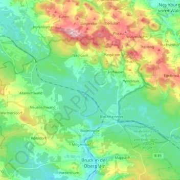
Name: Bodenwöhr topographic map, elevation, terrain.
Location: Bodenwöhr, Landkreis Schwandorf, Bavaria, 92439, Germany (49.26241 12.20544 49.33022 12.38090)
Average elevation: 425 m
Minimum elevation: 361 m
Maximum elevation: 567 m
Thank you for supporting this site ❤️
Make a donation
Make a donation
Gear up for your next adventure:
As an Amazon Associate, this site earns from qualifying purchases at no extra cost to you.
Other topographic maps
Click on a map to view its topography, its elevation and its terrain.
Bruck in der Oberpfalz
Germany > Bavaria > Landkreis Schwandorf > Bruck i.d.OPf.
Average elevation: 404 m