
Make a donation
Gear up for your next adventure:
As an Amazon Associate, this site earns from qualifying purchases at no extra cost to you.
Waginger See topographic map
Click on the map to display elevation.
Make a donation
Gear up for your next adventure:
As an Amazon Associate, this site earns from qualifying purchases at no extra cost to you.
Waginger See
Waginger See is a lake in the Alpine foothills, Bavaria, Germany. Geologically, it forms one single lake with the Tachinger See, with which it is connected through a narrow strait at Tettenhausen. The surface area of the Waginger See proper is 6.61 km2 (2.55 sq mi); combined with the Tachinger See it is 8.97 km2 (3.46 sq mi). Its elevation is 441 m (1,447 ft) and its drainage area is 163.66 km2 (63.19 sq mi). Its primary inflows are Schinderbach, Höllenbach and Tenglinger Bach, and it is drained by the Götzinger Achen.
Make a donation
Gear up for your next adventure:
As an Amazon Associate, this site earns from qualifying purchases at no extra cost to you.
About this map
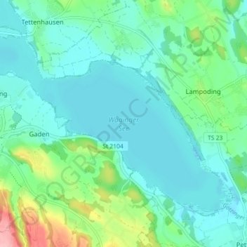
Name: Waginger See topographic map, elevation, terrain.
Average elevation: 464 m
Minimum elevation: 437 m
Maximum elevation: 565 m
Make a donation
Gear up for your next adventure:
As an Amazon Associate, this site earns from qualifying purchases at no extra cost to you.