Geolocate

Fairview topographic map

Click on the map to display elevation.

About this map

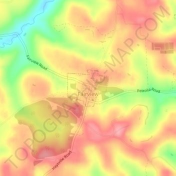
Name: Fairview topographic map, elevation, terrain.

Location: Fairview, Butler County, Pennsylvania, United States (41.01252 -79.74707 41.01828 -79.73875)

Average elevation: 412 m

Minimum elevation: 345 m

Maximum elevation: 451 m

Other topographic maps

Click on a map to view its topography, its elevation and its terrain.

Gear up for your next adventure:

🧴Sunscreen SPF - Sun protection for outdoor activities
🧼Clip-on Hand Sanitizer - Maintain hygiene when water for washing is scarce
🧳Outdoor Travel Organizers - Gear organization accessories
📷Backpack Camera Clips - Quick access to your camera while keeping your hands free for climbing
🛌Sleeping Mats - Insulated mats for camping comfort

As an Amazon Associate, this site earns from qualifying purchases at no extra cost to you.