
Château-d'Oex topographic map
Interactive map
Click on the map to display elevation.
About this map
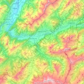
Name: Château-d'Oex topographic map, elevation, terrain.
Average elevation: 1,479 m
Minimum elevation: 732 m
Maximum elevation: 2,529 m
Other topographic maps
Click on a map to view its topography, its elevation and its terrain.
Jongny
Switzerland > Vaud > District de la Riviera-Pays-d’Enhaut > Jongny
Jongny, District de la Riviera-Pays-d’Enhaut, Vaud, 1805, Switzerland
Average elevation: 758 m