
Le Chambost topographic map
Interactive map
Click on the map to display elevation.
About this map
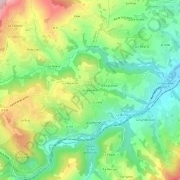
Name: Le Chambost topographic map, elevation, terrain.
Average elevation: 453 m
Minimum elevation: 298 m
Maximum elevation: 711 m
Other topographic maps
Click on a map to view its topography, its elevation and its terrain.
Le Charachon
France > Auvergne-Rhône-Alpes > Rhône > Brussieu
Le Charachon, Brussieu, Lyon, Rhône, Circonscription départementale du Rhône, Auvergne-Rhône-Alpes, France métropolitaine, 69690, France
Average elevation: 441 m