
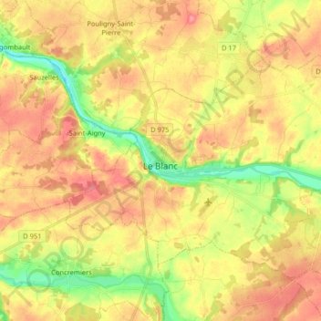
Le Blanc topographic map
Interactive map
Click on the map to display elevation.
About this map
Name: Le Blanc topographic map, elevation, terrain.
Average elevation: 111 m
Minimum elevation: 69 m
Maximum elevation: 144 m
Other topographic maps
Click on a map to view its topography, its elevation and its terrain.
Buzançais
France > Centre-Val de Loire > Indre
Buzançais, Châteauroux, Indre, Centre-Val de Loire, France métropolitaine, 36500, France
Average elevation: 130 m
Sainte-Sévère-sur-Indre
France > Centre-Val de Loire > Indre > Sainte-Sévère-sur-Indre
Sainte-Sévère-sur-Indre, La Châtre, Indre, Centre-Val de Loire, France métropolitaine, 36160, France
Average elevation: 287 m
Saint-Christophe-en-Boucherie
France > Centre-Val de Loire > Indre > Saint-Christophe-en-Boucherie
Saint-Christophe-en-Boucherie, La Châtre, Indre, Centre-Val de Loire, France métropolitaine, 36400, France
Average elevation: 237 m
Issoudun
France > Centre-Val de Loire > Indre > Issoudun
Issoudun, Indre, Centre-Val de Loire, France métropolitaine, 36100, France
Average elevation: 149 m
Châteauroux
France > Centre-Val de Loire > Indre > Châteauroux
Châteauroux, Indre, Centre-Val de Loire, France métropolitaine, 36000, France
Average elevation: 153 m
Éguzon-Chantôme
France > Centre-Val de Loire > Indre
Éguzon-Chantôme, Châteauroux, Indre, Centre-Val de Loire, France métropolitaine, 36270, France
Average elevation: 264 m
Saint-Valentin
France > Centre-Val de Loire > Indre
Saint-Valentin, Issoudun, Indre, Centre-Val de Loire, France métropolitaine, 36100, France
Average elevation: 164 m