
Make a donation
Gear up for your next adventure:
As an Amazon Associate, this site earns from qualifying purchases at no extra cost to you.
Morvan topographic map
Click on the map to display elevation.
Make a donation
Gear up for your next adventure:
As an Amazon Associate, this site earns from qualifying purchases at no extra cost to you.
Morvan
It is the smallest mountain area in France in terms of landmass covered, as well as the lowest, with a maximum altitude of 901 metres (2,956 feet) at Haut-Folin.
Make a donation
Gear up for your next adventure:
As an Amazon Associate, this site earns from qualifying purchases at no extra cost to you.
About this map
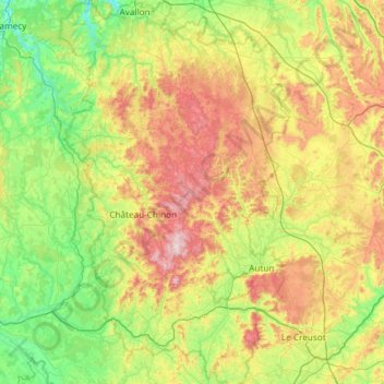
Name: Morvan topographic map, elevation, terrain.
Location: Morvan, Bourgogne-Franche-Comté, Metropolitan France, France (46.74221 3.58498 47.52833 4.49478)
Average elevation: 368 m
Minimum elevation: 133 m
Maximum elevation: 904 m
Make a donation
Gear up for your next adventure:
As an Amazon Associate, this site earns from qualifying purchases at no extra cost to you.