
O Someiro topographic map
Interactive map
Click on the map to display elevation.
About this map
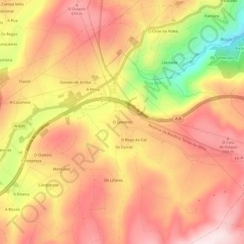
Name: O Someiro topographic map, elevation, terrain.
Average elevation: 560 m
Minimum elevation: 290 m
Maximum elevation: 717 m
Other topographic maps
Click on a map to view its topography, its elevation and its terrain.
O Cal
España > Galicia > Tierra Chá > Abadín
O Cal, Fanoi, Abadín, Tierra Chá, Lugo, Galicia, 27730, España
Average elevation: 568 m