
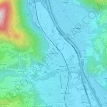
Niederaudorf topographic map
Interactive map
Click on the map to display elevation.
About this map
Name: Niederaudorf topographic map, elevation, terrain.
Average elevation: 590 m
Minimum elevation: 457 m
Maximum elevation: 1,404 m
Other topographic maps
Click on a map to view its topography, its elevation and its terrain.
Rosengasse
Deutschland > Bayern > Landkreis Rosenheim > Oberaudorf
Rosengasse, Oberaudorf, Landkreis Rosenheim, Bayern, 83735, Deutschland
Average elevation: 1,260 m
Buchau
Deutschland > Bayern > Landkreis Rosenheim > Oberaudorf
Buchau, Oberaudorf, Landkreis Rosenheim, Bayern, 83080, Deutschland
Average elevation: 876 m
Innsiedlung
Deutschland > Bayern > Landkreis Rosenheim > Oberaudorf
Innsiedlung, Oberaudorf, Landkreis Rosenheim, Bayern, 83080, Deutschland
Average elevation: 527 m
Tatzelwurm
Deutschland > Bayern > Landkreis Rosenheim > Oberaudorf
Tatzelwurm, Oberaudorf, Landkreis Rosenheim, Bayern, Deutschland
Average elevation: 996 m
Seebach
Deutschland > Bayern > Landkreis Rosenheim > Oberaudorf
Seebach, Oberaudorf, Landkreis Rosenheim, Bayern, Deutschland
Average elevation: 931 m
Unteres Sudelfeld
Deutschland > Bayern > Landkreis Rosenheim > Oberaudorf
Unteres Sudelfeld, Oberaudorf, Landkreis Rosenheim, Bayern, 83735, Deutschland
Average elevation: 1,145 m