
Garnich topographic map
Interactive map
Click on the map to display elevation.
About this map
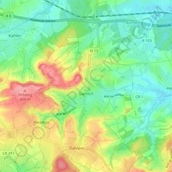
Name: Garnich topographic map, elevation, terrain.
Location: Garnich, Canton Capellen, Luxemburg (49.59124 5.89283 49.64165 5.97225)
Average elevation: 338 m
Minimum elevation: 299 m
Maximum elevation: 403 m
Other topographic maps
Click on a map to view its topography, its elevation and its terrain.
Grass
Luxemburg > Canton Capellen > Grass
Grass, Steinfort, Canton Capellen, 8362, Luxemburg
Average elevation: 332 m