Geolocate

Serres topographic map

Interactive map

Click on the map to display elevation.

About this map

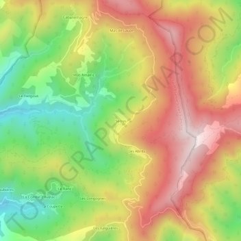
Name: Serres topographic map, elevation, terrain.

Location: Serres, Saint-Étienne-Vallée-Française, Florac, Lozère, Occitanie, France métropolitaine, 48330, France (44.17125 3.85462 44.21125 3.89462)

Average elevation: 598 m

Minimum elevation: 275 m

Maximum elevation: 908 m

Other topographic maps

Click on a map to view its topography, its elevation and its terrain.

Les Falguières

France > Occitanie > Lozère > Saint-Étienne-Vallée-Française > Les Falguières

Les Falguières, Saint-Étienne-Vallée-Française, Florac, Lozère, Occitanie, France métropolitaine, 48330, France

Average elevation: 507 m

Château de Cambiaire

France > Occitanie > Lozère > Saint-Étienne-Vallée-Française > Les Solièges

Château de Cambiaire, Rue de la Font de Bourre, Les Solièges, Saint-Étienne-Vallée-Française, Florac, Lozère, Occitanie, France métropolitaine, 48330, France

Average elevation: 351 m

Les Solièges

France > Occitanie > Lozère > Saint-Étienne-Vallée-Française

Les Solièges, Saint-Étienne-Vallée-Française, Florac, Lozère, Occitanie, France métropolitaine, 48330, France

Average elevation: 384 m

Les Passadoires

France > Occitanie > Lozère > Saint-Étienne-Vallée-Française

Les Passadoires, Saint-Étienne-Vallée-Française, Florac, Lozère, Occitanie, France métropolitaine, 48330, France

Average elevation: 408 m