
Make a donation
Gear up for your next adventure:
As an Amazon Associate, this site earns from qualifying purchases at no extra cost to you.
Großer Riedelstein topographic map
Click on the map to display elevation.
Make a donation
Gear up for your next adventure:
As an Amazon Associate, this site earns from qualifying purchases at no extra cost to you.
Großer Riedelstein
Der Große Riedelstein bildet mit seiner Höhe von 1132,9 m ü. NHN den höchsten Punkt des Kaitersberges im Bayerischen Wald. Seinen felsigen Gipfel schmückt das steinerne Denkmal zu Ehren des Dichters Maximilian Schmidt, genannt Waldschmidt.
Make a donation
Gear up for your next adventure:
As an Amazon Associate, this site earns from qualifying purchases at no extra cost to you.
About this map
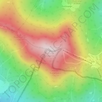
Name: Großer Riedelstein topographic map, elevation, terrain.
Average elevation: 839 m
Minimum elevation: 575 m
Maximum elevation: 1,107 m
Make a donation
Gear up for your next adventure:
As an Amazon Associate, this site earns from qualifying purchases at no extra cost to you.