
Korgalzhyn District topographic map
Interactive map
Click on the map to display elevation.
About this map
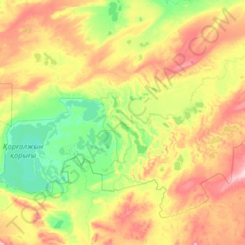
Name: Korgalzhyn District topographic map, elevation, terrain.
Location: Korgalzhyn District, Akmola Region, Kazakhstan (50.03919 68.67393 51.11492 70.85371)
Average elevation: 346 m
Minimum elevation: 300 m
Maximum elevation: 463 m
Other topographic maps
Click on a map to view its topography, its elevation and its terrain.
Qorğaljın
Kazakhstan > Akmola Region > Qorğaljın district
The village is located on the Kazakh Uplands. The average altitude in the village is about 330 meters above sea level. The terrain is a continuous plain with small hills and water areas.
Average elevation: 330 m