
Bulgan topographic map
Interactive map
Click on the map to display elevation.
About this map
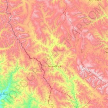
Name: Bulgan topographic map, elevation, terrain.
Location: Bulgan, Bajan-Ölgii, Mongolei (46.54169 90.53649 47.51805 91.92712)
Average elevation: 2,672 m
Minimum elevation: 1,206 m
Maximum elevation: 4,161 m
Other topographic maps
Click on a map to view its topography, its elevation and its terrain.
Цэнгэл ᠴᠡᠩᠭᠡᠯ
Mongolei > Bajan-Ölgii > Tsengel
Цэнгэл ᠴᠡᠩᠭᠡᠯ, Tsengel, Bajan-Ölgii, Mongolei
Average elevation: 1,955 m