
Make a donation
Gear up for your next adventure:
As an Amazon Associate, this site earns from qualifying purchases at no extra cost to you.
Brighton topographic map
Click on the map to display elevation.
Make a donation
Gear up for your next adventure:
As an Amazon Associate, this site earns from qualifying purchases at no extra cost to you.
About this map
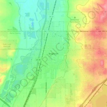
Name: Brighton topographic map, elevation, terrain.
Location: Brighton, Adams County, Colorado, 80601, United States (39.94372 -104.85108 40.02372 -104.77108)
Average elevation: 1,533 m
Minimum elevation: 1,497 m
Maximum elevation: 1,582 m
Make a donation
Gear up for your next adventure:
As an Amazon Associate, this site earns from qualifying purchases at no extra cost to you.
Other topographic maps
Click on a map to view its topography, its elevation and its terrain.
Make a donation
Gear up for your next adventure:
As an Amazon Associate, this site earns from qualifying purchases at no extra cost to you.
Rocky Mountain Arsenal National Wildlife Refuge
United States > Colorado > Adams County
Average elevation: 1,592 m
Make a donation
Gear up for your next adventure:
As an Amazon Associate, this site earns from qualifying purchases at no extra cost to you.