
Churchill topographic map
Interactive map
Click on the map to display elevation.
About this map
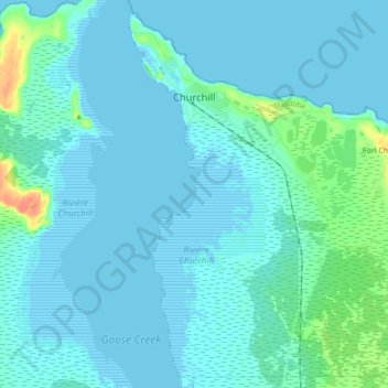
Name: Churchill topographic map, elevation, terrain.
Location: Churchill, Manitoba, Canada (58.70139 -94.20449 58.79004 -94.02337)
Average elevation: 5 m
Minimum elevation: -2 m
Maximum elevation: 40 m
Other topographic maps
Click on a map to view its topography, its elevation and its terrain.
Goulbourne
Canada > Manitoba > Division No. 18 > Municipality of West Interlake
Average elevation: 251 m