
Thank you for supporting this site ❤️
Make a donation
Make a donation
Gear up for your next adventure:
As an Amazon Associate, this site earns from qualifying purchases at no extra cost to you.
Ajijic topographic map
Click on the map to display elevation.
Thank you for supporting this site ❤️
Make a donation
Make a donation
Gear up for your next adventure:
As an Amazon Associate, this site earns from qualifying purchases at no extra cost to you.
About this map
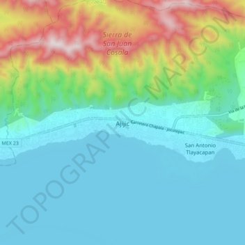
Name: Ajijic topographic map, elevation, terrain.
Location: Ajijic, Chapala, Jalisco, 45920, Mexico (20.26020 -103.30193 20.34020 -103.22193)
Average elevation: 1,738 m
Minimum elevation: 1,515 m
Maximum elevation: 2,450 m
Thank you for supporting this site ❤️
Make a donation
Make a donation
Gear up for your next adventure:
As an Amazon Associate, this site earns from qualifying purchases at no extra cost to you.