
Make a donation
Gear up for your next adventure:
As an Amazon Associate, this site earns from qualifying purchases at no extra cost to you.
Hohe Wurzel topographic map
Click on the map to display elevation.
Make a donation
Gear up for your next adventure:
As an Amazon Associate, this site earns from qualifying purchases at no extra cost to you.
Hohe Wurzel
Die Hohe Wurzel ist eher ein langgestreckter Höhenzug als ein markanter Berg, neben dem höheren Rösterkopf wirkt sie wie dessen Nordostausläufer. Auffallend ist eine Höchstspannungsfreileitung zwischen den Umspannwerken Uchtelfangen und Niederstedem, die die Hohe Wurzel in einer Waldschneise fast zentral überquert.
Make a donation
Gear up for your next adventure:
As an Amazon Associate, this site earns from qualifying purchases at no extra cost to you.
About this map
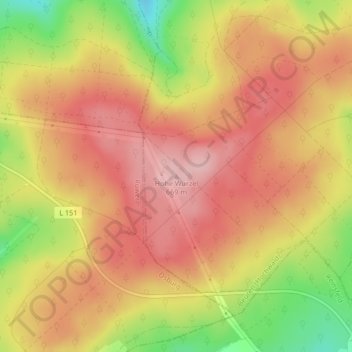
Name: Hohe Wurzel topographic map, elevation, terrain.
Average elevation: 612 m
Minimum elevation: 508 m
Maximum elevation: 674 m
Make a donation
Gear up for your next adventure:
As an Amazon Associate, this site earns from qualifying purchases at no extra cost to you.