
Lac Duhamel topographic map
Interactive map
Click on the map to display elevation.
About this map
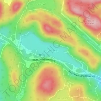
Name: Lac Duhamel topographic map, elevation, terrain.
Average elevation: 312 m
Minimum elevation: 218 m
Maximum elevation: 420 m
Other topographic maps
Click on a map to view its topography, its elevation and its terrain.
Lac Moore
Canada > Quebec > Les Laurentides > Mont-Tremblant
Lac Moore, Mont-Tremblant-Village, Mont-Tremblant, Les Laurentides, Laurentides, Quebec, Canada
Average elevation: 280 m
Lac Maskinongé
Canada > Quebec > Les Laurentides > Mont-Tremblant
Lac Maskinongé, Mont-Tremblant, Les Laurentides, Laurentides, Quebec, Canada
Average elevation: 235 m