
Make a donation
Gear up for your next adventure:
As an Amazon Associate, this site earns from qualifying purchases at no extra cost to you.
Rancho Cucamonga topographic map
Click on the map to display elevation.
Make a donation
Gear up for your next adventure:
As an Amazon Associate, this site earns from qualifying purchases at no extra cost to you.
About this map
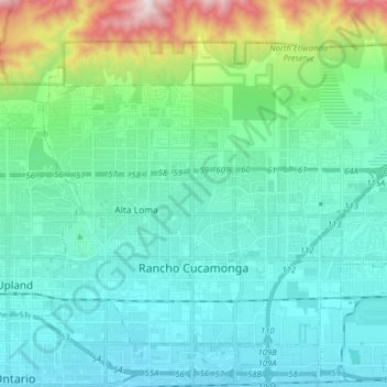
Name: Rancho Cucamonga topographic map, elevation, terrain.
Average elevation: 532 m
Minimum elevation: 290 m
Maximum elevation: 1,660 m
Make a donation
Gear up for your next adventure:
As an Amazon Associate, this site earns from qualifying purchases at no extra cost to you.
Other topographic maps
Click on a map to view its topography, its elevation and its terrain.
Lake Gregory
United States > California > San Bernardino County > Crestline
Average elevation: 1,452 m
Sam Alba Memorial Park
United States > California > San Bernardino County > Ontario
Average elevation: 296 m
Make a donation
Gear up for your next adventure:
As an Amazon Associate, this site earns from qualifying purchases at no extra cost to you.
High Country
United States > California > San Bernardino County > Hesperia > High Country
Average elevation: 1,104 m