
Make a donation
Gear up for your next adventure:
As an Amazon Associate, this site earns from qualifying purchases at no extra cost to you.
As Sulayyil topographic map
Click on the map to display elevation.
Make a donation
Gear up for your next adventure:
As an Amazon Associate, this site earns from qualifying purchases at no extra cost to you.
About this map
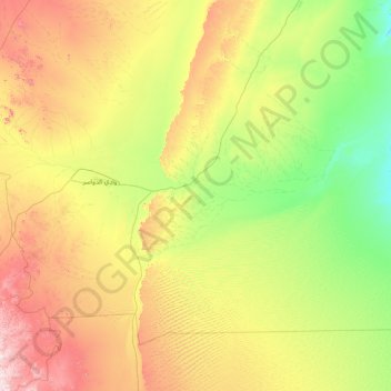
Name: As Sulayyil topographic map, elevation, terrain.
Location: As Sulayyil, Riyadh Region, Saudi Arabia (19.20833 45.01406 21.48546 48.18380)
Average elevation: 741 m
Minimum elevation: 440 m
Maximum elevation: 1,645 m
Make a donation
Gear up for your next adventure:
As an Amazon Associate, this site earns from qualifying purchases at no extra cost to you.
Other topographic maps
Click on a map to view its topography, its elevation and its terrain.
Riyadh
Riyadh has a hot desert climate (Köppen Climate Classification BWh), with long, extremely hot summers and short, very mild winters. The average high temperature in August is 43.6 °C (110.5 °F). If not for the elevation the city was on, Riyadh would experience an even hotter climate. The city experiences…
Average elevation: 630 m