Geolocate

Manatí topographic map

Click on the map to display elevation.

About this map

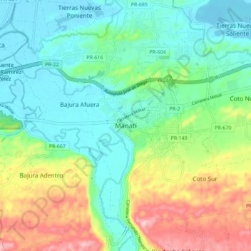
Name: Manatí topographic map, elevation, terrain.

Location: Manatí, Puerto Rico, 00701, United States (18.38714 -66.53295 18.46714 -66.45295)

Average elevation: 68 m

Minimum elevation: -2 m

Maximum elevation: 217 m

Gear up for your next adventure:

🚴Bike GPS - GPS devices for cycling
📣High-Decibel Survival Whistles - Signaling tool for rescue that carries much further than a human voice
🎧Bluetooth Outdoor Earbuds - Listen to navigation cues or podcasts during long solo treks
Outdoor Coffee Makers - Enjoy quality coffee at the summit of your favorite peak
🧳Outdoor Travel Organizers - Gear organization accessories

As an Amazon Associate, this site earns from qualifying purchases at no extra cost to you.