
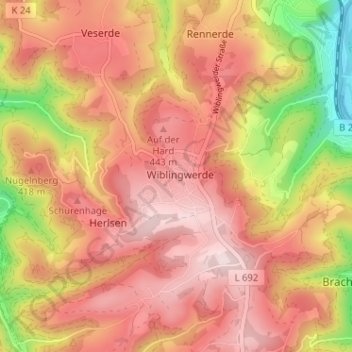
Wiblingwerde topographic map
Interactive map
Click on the map to display elevation.
About this map
Name: Wiblingwerde topographic map, elevation, terrain.
Average elevation: 362 m
Minimum elevation: 141 m
Maximum elevation: 494 m
Other topographic maps
Click on a map to view its topography, its elevation and its terrain.
Dümpel
Deutschland > Nordrhein-Westfalen > Märkischer Kreis > Nachrodt-Wiblingwerde
Dümpel, Nachrodt-Wiblingwerde, Märkischer Kreis, Nordrhein-Westfalen, 58769, Deutschland
Average elevation: 292 m
Veserde
Deutschland > Nordrhein-Westfalen > Märkischer Kreis > Nachrodt-Wiblingwerde
Veserde, Nachrodt-Wiblingwerde, Märkischer Kreis, Nordrhein-Westfalen, 58769, Deutschland
Average elevation: 317 m
Rennerde
Deutschland > Nordrhein-Westfalen > Märkischer Kreis > Nachrodt-Wiblingwerde
Rennerde, Nachrodt-Wiblingwerde, Märkischer Kreis, Nordrhein-Westfalen, 58769, Deutschland
Average elevation: 306 m