
Make a donation
Gear up for your next adventure:
As an Amazon Associate, this site earns from qualifying purchases at no extra cost to you.
Wilmington topographic map
Click on the map to display elevation.
Make a donation
Gear up for your next adventure:
As an Amazon Associate, this site earns from qualifying purchases at no extra cost to you.
Wilmington
Wilmington experiences a humid continental climate (Koppen Dfb) with warm, humid summers and cold (sometimes severely cold) winters. While snowfall can vary greatly from year to year in nearby towns like Bennington and Brattleboro, Wilmington's snowfall is consistently heavy each year because of its elevation in the Green Mountains' high country.
Make a donation
Gear up for your next adventure:
As an Amazon Associate, this site earns from qualifying purchases at no extra cost to you.
About this map
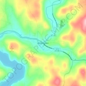
Name: Wilmington topographic map, elevation, terrain.
Location: Wilmington, Windham County, Vermont, 05363, United States (42.84852 -72.89102 42.88852 -72.85102)
Average elevation: 515 m
Minimum elevation: 441 m
Maximum elevation: 620 m
Make a donation
Gear up for your next adventure:
As an Amazon Associate, this site earns from qualifying purchases at no extra cost to you.