
Make a donation
Gear up for your next adventure:
As an Amazon Associate, this site earns from qualifying purchases at no extra cost to you.
Blue Canyon topographic map
Click on the map to display elevation.
Make a donation
Gear up for your next adventure:
As an Amazon Associate, this site earns from qualifying purchases at no extra cost to you.
Blue Canyon
Blue Canyon (also, Blue Cañon) is an unincorporated community in Placer County, California. Blue Canyon is located 4 miles (6.4 km) southwest of Emigrant Gap. It lies at an elevation of 4695 feet (1431 m).
Make a donation
Gear up for your next adventure:
As an Amazon Associate, this site earns from qualifying purchases at no extra cost to you.
About this map
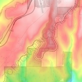
Name: Blue Canyon topographic map, elevation, terrain.
Average elevation: 1,452 m
Minimum elevation: 1,071 m
Maximum elevation: 1,612 m
Make a donation
Gear up for your next adventure:
As an Amazon Associate, this site earns from qualifying purchases at no extra cost to you.
Other topographic maps
Click on a map to view its topography, its elevation and its terrain.
Make a donation
Gear up for your next adventure:
As an Amazon Associate, this site earns from qualifying purchases at no extra cost to you.
North Tahoe Regional Park
United States > California > Placer County > Tahoe Vista
Average elevation: 2,007 m
Make a donation
Gear up for your next adventure:
As an Amazon Associate, this site earns from qualifying purchases at no extra cost to you.