
Make a donation
Gear up for your next adventure:
As an Amazon Associate, this site earns from qualifying purchases at no extra cost to you.
Neunkirchen am Main topographic map
Click on the map to display elevation.
Make a donation
Gear up for your next adventure:
As an Amazon Associate, this site earns from qualifying purchases at no extra cost to you.
Neunkirchen am Main
Neunkirchen am Main (amtlich: Neunkirchen a.Main) ist ein Gemeindeteil des Markts Weidenberg im oberfränkischen Landkreis Bayreuth. Die Ortschaft liegt am Hang einer Anhöhe zwischen den Tälern des Roten Mains und der in ihn mündenden Ölschnitz.
Make a donation
Gear up for your next adventure:
As an Amazon Associate, this site earns from qualifying purchases at no extra cost to you.
About this map
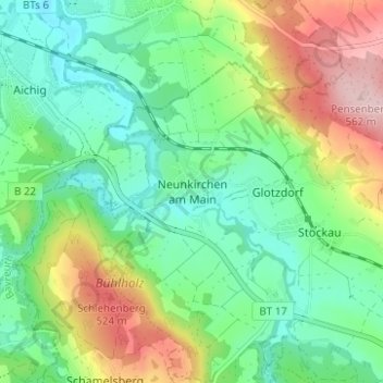
Name: Neunkirchen am Main topographic map, elevation, terrain.
Average elevation: 419 m
Minimum elevation: 345 m
Maximum elevation: 564 m
Make a donation
Gear up for your next adventure:
As an Amazon Associate, this site earns from qualifying purchases at no extra cost to you.