
Burlats topographic map
Interactive map
Click on the map to display elevation.
About this map
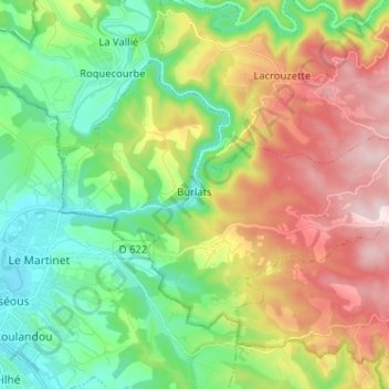
Name: Burlats topographic map, elevation, terrain.
Average elevation: 357 m
Minimum elevation: 169 m
Maximum elevation: 664 m
Other topographic maps
Click on a map to view its topography, its elevation and its terrain.
Lac du Merle
France > Occitanie > Tarn > Burlats
Lac du Merle, Burlats, Castres, Tarn, Occitanie, France métropolitaine, 81100, France
Average elevation: 633 m