
Ocotepeque topographic map
Interactive map
Click on the map to display elevation.
About this map
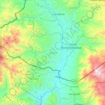
Name: Ocotepeque topographic map, elevation, terrain.
Location: Ocotepeque, Honduras (14.36475 -89.33427 14.48581 -89.10863)
Average elevation: 1,250 m
Minimum elevation: 637 m
Maximum elevation: 2,704 m
Other topographic maps
Click on a map to view its topography, its elevation and its terrain.
Belén Gualcho
Honduras > Ocotepeque > Belén Gualcho
Belén Gualcho, Ocotepeque, Honduras
Average elevation: 1,765 m
Dolores Merendón
Honduras > Ocotepeque > Dolores Merendón
Dolores Merendón, Ocotepeque, Honduras
Average elevation: 1,542 m