
Hiam District topographic map
Interactive map
Click on the map to display elevation.
About this map
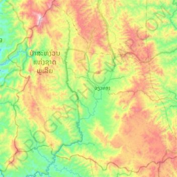
Name: Hiam District topographic map, elevation, terrain.
Location: Hiam District, Houaphanh, Laos (19.86566 103.10735 20.30699 103.60211)
Average elevation: 1,096 m
Minimum elevation: 491 m
Maximum elevation: 2,253 m
Other topographic maps
Click on a map to view its topography, its elevation and its terrain.
Him
Laos > Houaphanh > Xam Neua District
Him, Xam Neua District, Houaphanh, Laos
Average elevation: 897 m
Naka
Laos > Houaphanh > Sop Bao District
Naka, Sop Bao District, Houaphanh, Laos
Average elevation: 337 m