
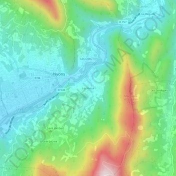
Les Rieux topographic map
Interactive map
Click on the map to display elevation.
About this map
Name: Les Rieux topographic map, elevation, terrain.
Average elevation: 434 m
Minimum elevation: 246 m
Maximum elevation: 902 m
Other topographic maps
Click on a map to view its topography, its elevation and its terrain.
Saint-Jaume
France > Auvergne-Rhône-Alpes > Drôme > Nyons
Saint-Jaume, Nyons, Drôme, Auvergne-Rhône-Alpes, France métropolitaine, 26110, France
Average elevation: 540 m
Les Clots
France > Auvergne-Rhône-Alpes > Drôme > Nyons
Les Clots, Nyons, Drôme, Auvergne-Rhône-Alpes, France métropolitaine, 26110, France
Average elevation: 420 m
Saint Rimbert
France > Auvergne-Rhône-Alpes > Drôme > Nyons
Saint Rimbert, Nyons, Drôme, Auvergne-Rhône-Alpes, France métropolitaine, 26110, France
Average elevation: 441 m