
Tring topographic map
Click on the map to display elevation.
About this map
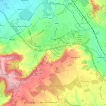
Name: Tring topographic map, elevation, terrain.
Location: Tring, Dacorum, Hertfordshire, England, United Kingdom (51.75304 -0.69022 51.81803 -0.62378)
Average elevation: 168 m
Minimum elevation: 87 m
Maximum elevation: 270 m
Other topographic maps
Click on a map to view its topography, its elevation and its terrain.
Tringford Reservoir
United Kingdom > England > Hertfordshire > Dacorum > Tring > Wilstone
Average elevation: 119 m
Long Marston
United Kingdom > England > Hertfordshire > Dacorum > Long Marston
Average elevation: 92 m
Saint Margarets Copse
United Kingdom > England > Hertfordshire > Dacorum > Great Gaddesden
Average elevation: 144 m
Hammerfield
United Kingdom > England > Hertfordshire > Dacorum > Hemel Hempstead
Average elevation: 122 m
Dixon's Gap Bridge
United Kingdom > England > Hertfordshire > Dacorum > Wilstone > Gubblecote
Average elevation: 101 m
Westbrook Mere
United Kingdom > England > Hertfordshire > Dacorum > Bourne End
Average elevation: 125 m
Trowley Bottom
United Kingdom > England > Hertfordshire > Dacorum > Flamstead
Average elevation: 139 m
Nettleden
United Kingdom > England > Hertfordshire > Dacorum > Great Gaddesden
Average elevation: 149 m
Bovingdon Green
United Kingdom > England > Hertfordshire > Dacorum > Bovingdon
Average elevation: 151 m
Frithsden Beeches
United Kingdom > England > Hertfordshire > Dacorum > Potten End
Average elevation: 160 m