
Thank you for supporting this site ❤️
Make a donation
Make a donation
Gear up for your next adventure:
As an Amazon Associate, this site earns from qualifying purchases at no extra cost to you.
Reforma topographic map
Click on the map to display elevation.
Thank you for supporting this site ❤️
Make a donation
Make a donation
Gear up for your next adventure:
As an Amazon Associate, this site earns from qualifying purchases at no extra cost to you.
About this map
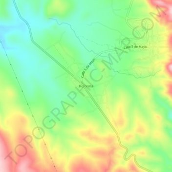
Name: Reforma topographic map, elevation, terrain.
Location: Reforma, Zapotitlán Palmas, Oaxaca, 69062, México (17.86056 -97.85417 17.90056 -97.81417)
Average elevation: 1,899 m
Minimum elevation: 1,808 m
Maximum elevation: 2,027 m
Thank you for supporting this site ❤️
Make a donation
Make a donation
Gear up for your next adventure:
As an Amazon Associate, this site earns from qualifying purchases at no extra cost to you.