
Make a donation
Gear up for your next adventure:
As an Amazon Associate, this site earns from qualifying purchases at no extra cost to you.
Windhoek topographic map
Click on the map to display elevation.
Make a donation
Gear up for your next adventure:
As an Amazon Associate, this site earns from qualifying purchases at no extra cost to you.
Windhoek
Windhoek has over 300 sunny days per year. It experiences a hot semi-arid climate (BSh) according to Köppen climate classification as the annual average temperature is above 18 °C (64 °F). The temperature throughout the year would be called mild, due to altitude influence. The annual average high and low temperature range is 13.4 °C (24.1 °F). The coldest month is July, with an average temperature of 13.1 °C (55.6 °F), while the hottest month is December, with average temperature 23.5 °C (74.3 °F). Due to its location near the Kalahari Desert, the city receives 3,605 hours of sunshine. Precipitation is abundant during the summer season, and minimal during the winter season. The average annual precipitation is 367.4 mm (14.46 in), with lows of 106.7 mm (4.20 in) in the 2018/19 rainy season, and 97 mm (3.8 in) in 1929/30.
Make a donation
Gear up for your next adventure:
As an Amazon Associate, this site earns from qualifying purchases at no extra cost to you.
About this map
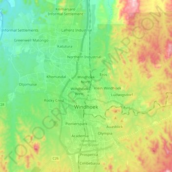
Name: Windhoek topographic map, elevation, terrain.
Location: Windhoek, Khomas, Namibia (-22.63866 16.98687 -22.42857 17.13062)
Average elevation: 1,679 m
Minimum elevation: 1,442 m
Maximum elevation: 2,109 m
Make a donation
Gear up for your next adventure:
As an Amazon Associate, this site earns from qualifying purchases at no extra cost to you.
Other topographic maps
Click on a map to view its topography, its elevation and its terrain.
Windhoek
Windhoek has over 300 sunny days per year. It experiences a hot semi-arid climate (BSh) according to Köppen climate classification as the annual average temperature is above 18 °C (64 °F). The temperature throughout the year would be called mild, due to altitude influence. The annual average high and low…
Average elevation: 1,710 m
Make a donation
Gear up for your next adventure:
As an Amazon Associate, this site earns from qualifying purchases at no extra cost to you.