
Bazoches topographic map
Interactive map
Click on the map to display elevation.
About this map
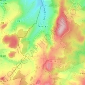
Name: Bazoches topographic map, elevation, terrain.
Average elevation: 305 m
Minimum elevation: 192 m
Maximum elevation: 416 m
Other topographic maps
Click on a map to view its topography, its elevation and its terrain.
Bouhy
France > Bourgogne-Franche-Comté > Nièvre
Bouhy, Cosne-Cours-sur-Loire, Nièvre, Bourgogne-Franche-Comté, Metropolitan France, 58310, France
Average elevation: 271 m