
Deschutes County topographic map
Interactive map
Click on the map to display elevation.
About this map
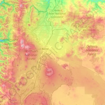
Name: Deschutes County topographic map, elevation, terrain.
Location: Deschutes County, Oregon, USA (43.61106 -122.00251 44.39352 -119.89658)
Average elevation: 1,324 m
Minimum elevation: 423 m
Maximum elevation: 3,082 m
Other topographic maps
Click on a map to view its topography, its elevation and its terrain.
The Villages at Mount Hood
USA > Oregon > The Villages at Mount Hood
The Villages at Mount Hood, Clackamas County, Oregon, USA
Average elevation: 797 m
Jefferson Park Glacier
Jefferson Park Glacier, Pacific Crest Trail #2000, Jefferson County, Oregon, USA
Average elevation: 2,421 m
Linn Glacier
Linn Glacier, Pacific Crest Trail, Deschutes County, Oregon, USA
Average elevation: 2,359 m
Whitewater Glacier
Whitewater Glacier, Pacific Crest Trail, Jefferson County, Oregon, USA
Average elevation: 2,460 m
Cascade Head
USA > Oregon > Three Rocks
Cascade Head, Cascade Head Trail, Three Rocks, Tillamook County, Oregon, 97149, USA
Average elevation: 50 m
Bend Glacier
Bend Glacier, Broken Top NW Ridge route, Deschutes County, Oregon, USA
Average elevation: 2,350 m
Hayden Glacier
Hayden Glacier, climber's trail, Deschutes County, Oregon, USA
Average elevation: 2,542 m
Eliot Glacier
Eliot Glacier, Eliot west moraine, Hood River County, Oregon, USA
Average elevation: 2,316 m
Zigzag Glacier
Zigzag Glacier, Mountaineer Trail #798, Clackamas County, Oregon, USA
Average elevation: 2,620 m
Renfrew Glacier
Renfrew Glacier, climber's trail, Deschutes County, Oregon, USA
Average elevation: 2,538 m
Glisan Glacier
Glisan Glacier, McNeil Point Trail #600M, Hood River County, Oregon, USA
Average elevation: 2,086 m
Carver Glacier
Carver Glacier, South Sister Climber Trail #36, Deschutes County, Oregon, USA
Average elevation: 2,385 m
Reid Glacier
Reid Glacier, Yocum Ridge Trail #771, Clackamas County, Oregon, USA
Average elevation: 2,410 m
Ladd Glacier
Ladd Glacier, Barrett Spur, Hood River County, Oregon, USA
Average elevation: 2,305 m
Langille Glacier
Langille Glacier, Eliot west moraine, Hood River County, Oregon, USA
Average elevation: 2,165 m
Villard Glacier
Villard Glacier, climber's trail, Deschutes County, Oregon, USA
Average elevation: 2,448 m
Irving Glacier
Irving Glacier, Camp Lake Trail, Deschutes County, Oregon, USA
Average elevation: 2,344 m
Skinner Glacier
Skinner Glacier, South Sister Climber Trail #36, Deschutes County, Oregon, USA
Average elevation: 2,480 m
Wallowa Mountains
Wallowa Mountains, Wallowa County, Oregon, USA
Average elevation: 2,475 m
Benson Glacier
Benson Glacier, Eagle Cap Summit Trail, Union County, Oregon, USA
Average elevation: 2,489 m
Three Fingered Jack
Three Fingered Jack, Linn County, Oregon, USA
Average elevation: 1,881 m
Waldo Glacier
Waldo Glacier, Pacific Crest Trail, Jefferson County, Oregon, USA
Average elevation: 2,352 m
Prouty Glacier
Prouty Glacier, South Sister Climber Trail #36, Deschutes County, Oregon, USA
Average elevation: 2,589 m
Clark Glacier
Clark Glacier, South Sister Climber Trail #36, Deschutes County, Oregon, USA
Average elevation: 2,578 m
Crook Glacier
Crook Glacier, Broken Top NW Ridge route, Deschutes County, Oregon, USA
Average elevation: 2,347 m
White River Glacier
White River Glacier, Mountaineer Trail #798, Clackamas County, Oregon, USA
Average elevation: 2,523 m
Lathrop Glacier
Lathrop Glacier, Mt. Thielsen climber's trail, Douglas County, Oregon, USA
Average elevation: 2,235 m