
Make a donation
Gear up for your next adventure:
As an Amazon Associate, this site earns from qualifying purchases at no extra cost to you.
Rio Tejo topographic map
Click on the map to display elevation.
Make a donation
Gear up for your next adventure:
As an Amazon Associate, this site earns from qualifying purchases at no extra cost to you.
About this map
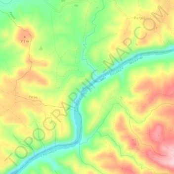
Name: Rio Tejo topographic map, elevation, terrain.
Average elevation: 160 m
Minimum elevation: 61 m
Maximum elevation: 264 m
Make a donation
Gear up for your next adventure:
As an Amazon Associate, this site earns from qualifying purchases at no extra cost to you.
Other topographic maps
Click on a map to view its topography, its elevation and its terrain.
Make a donation
Gear up for your next adventure:
As an Amazon Associate, this site earns from qualifying purchases at no extra cost to you.
Make a donation
Gear up for your next adventure:
As an Amazon Associate, this site earns from qualifying purchases at no extra cost to you.
Monumento Natural das Portas de Ródão
Portugal > Castelo Branco > Vila Velha de Ródão
Average elevation: 167 m
Make a donation
Gear up for your next adventure:
As an Amazon Associate, this site earns from qualifying purchases at no extra cost to you.
Gavião do Ródão
Portugal > Castelo Branco > Vila Velha de Ródão > Gavião do Ródão
Average elevation: 261 m