Geolocate

Romanina topographic map

Click on the map to display elevation.

About this map
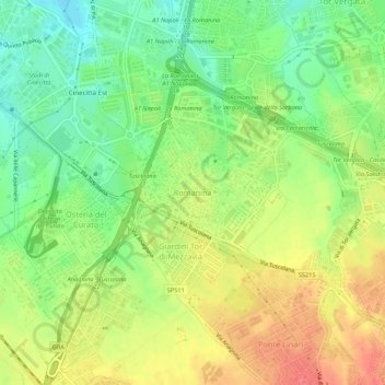
Name: Romanina topographic map, elevation, terrain.

Location: Romanina, Rome, Roma Capitale, Lazio, 00173, Italy (41.82064 12.57961 41.86064 12.61961)

Average elevation: 76 m

Minimum elevation: 46 m

Maximum elevation: 108 m

Other topographic maps

Click on a map to view its topography, its elevation and its terrain.

Villa Borghese Park

Italy > Lazio > Roma Capitale > Rome

Average elevation: 52 m

Villa Doria Pamphilj

Italy > Lazio > Roma Capitale > Rome

Average elevation: 67 m

Villa Celimontana

Italy > Lazio > Roma Capitale > Rome

Average elevation: 41 m

Tiber Island

Italy > Lazio > Roma Capitale > Rome

Average elevation: 38 m

Parco del Ninfeo

Italy > Lazio > Roma Capitale > Rome

Average elevation: 27 m

Gear up for your next adventure:

🕶️Polarized Outdoor Sunglasses - Reduce glare from rocks and water for better visual navigation
🍳Camping Cookware - Cookware sets for outdoor meals
📕Australia Maps - Maps covering Australian regions
🔑Heavy Duty Carabiners - Secure gear to the outside of your pack for easy access
🛌Compact Down Sleeping Bags - Warmth without the bulk, ideal for backcountry camping

As an Amazon Associate, this site earns from qualifying purchases at no extra cost to you.