
Make a donation
Gear up for your next adventure:
As an Amazon Associate, this site earns from qualifying purchases at no extra cost to you.
Macomb Township topographic map
Click on the map to display elevation.
Make a donation
Gear up for your next adventure:
As an Amazon Associate, this site earns from qualifying purchases at no extra cost to you.
About this map
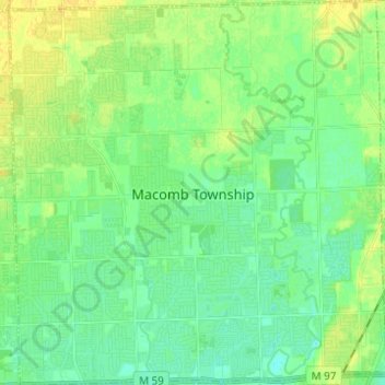
Name: Macomb Township topographic map, elevation, terrain.
Location: Macomb Township, Macomb County, Michigan, United States (42.62753 -82.97691 42.71813 -82.85610)
Average elevation: 186 m
Minimum elevation: 178 m
Maximum elevation: 197 m
Make a donation
Gear up for your next adventure:
As an Amazon Associate, this site earns from qualifying purchases at no extra cost to you.
Other topographic maps
Click on a map to view its topography, its elevation and its terrain.
Anchor Bay Shores
United States > Michigan > Macomb County > Chesterfield Township
Average elevation: 176 m
Preston Corners
United States > Michigan > Macomb County > Shelby Charter Township
Average elevation: 198 m
Make a donation
Gear up for your next adventure:
As an Amazon Associate, this site earns from qualifying purchases at no extra cost to you.
Shelby Charter Township
United States > Michigan > Macomb County > Shelby Charter Township
Average elevation: 205 m
Sterling Heights
United States > Michigan > Macomb County > Sterling Heights > Sterling Heights
Average elevation: 205 m