Geolocate

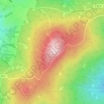
Großer Feldberg topographic map

Click on the map to display elevation.

Großer Feldberg

The Großer Feldberg ('Great Field Mountain') is, at a height of 879.5 metres, the highest elevation of the Taunus mountains, and of the entire Rhenish Massif. It is situated in the Hochtaunuskreis district in Hesse, Germany.

Wikipedia (CC-BY-SA 3.0)

About this map

Name: Großer Feldberg topographic map, elevation, terrain.

Location: Großer Feldberg, Schmitten im Taunus, Hochtaunuskreis, Hesse, 61389, Germany (50.23177 8.45678 50.23187 8.45688)

Average elevation: 716 m

Minimum elevation: 549 m

Maximum elevation: 884 m

Gear up for your next adventure:

🧴SPF 50+ Bulk Sunscreen - Maximum protection for long-term outdoor exposure
🔌Fast Charging Adapters - Quickly top up all your gear before heading back into the field
💡Collapsible Camping Lanterns - Illuminate your base camp or tent for map studying at night
🗺️Topographic Maps - Detailed maps for hiking and navigation
🎒Tactical Waist Packs - Quick access to your compass, phone, and snacks while walking

As an Amazon Associate, this site earns from qualifying purchases at no extra cost to you.