
Thank you for supporting this site ❤️
Make a donation
Make a donation
Gear up for your next adventure:
As an Amazon Associate, this site earns from qualifying purchases at no extra cost to you.
Manzanillo topographic map
Click on the map to display elevation.
Thank you for supporting this site ❤️
Make a donation
Make a donation
Gear up for your next adventure:
🧭Military Style Lensatic Compass - Durable sighting compasses for advanced land navigation and surveying
As an Amazon Associate, this site earns from qualifying purchases at no extra cost to you.
About this map
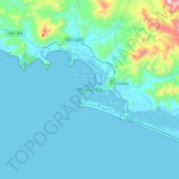
Name: Manzanillo topographic map, elevation, terrain.
Location: Manzanillo, Colima, 28200, Mexico (18.89063 -104.47600 19.21063 -104.15600)
Average elevation: 114 m
Minimum elevation: -2 m
Maximum elevation: 1,186 m
Thank you for supporting this site ❤️
Make a donation
Make a donation
Gear up for your next adventure:
🆘Personal Locator Beacons (PLB) - Satellite emergency beacons for life-saving help in areas with no mobile coverage
As an Amazon Associate, this site earns from qualifying purchases at no extra cost to you.