Geolocate

Westray topographic map

Click on the map to display elevation.

About this map

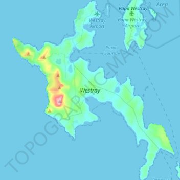
Name: Westray topographic map, elevation, terrain.

Location: Westray, Midbea, Orkney Islands, Scotland, United Kingdom (59.22828 -3.07151 59.36058 -2.83649)

Average elevation: 6 m

Minimum elevation: -1 m

Maximum elevation: 167 m

Gear up for your next adventure:

🛌Sleeping Bags - Sleeping bags for outdoor camping
🧼Biodegradable Outdoor Soap - Clean gear and yourself without harming the local ecosystem
🧭Compass - Navigation compasses for outdoor exploration
🧺Waterproof Dry Sacks - Organize your pack and keep electronics safe from rain and river crossings
🦘Outback Survival Gear - Essential gear for Australian outback

As an Amazon Associate, this site earns from qualifying purchases at no extra cost to you.