
Make a donation
Gear up for your next adventure:
As an Amazon Associate, this site earns from qualifying purchases at no extra cost to you.
Nyiragongo topographic map
Click on the map to display elevation.
Make a donation
Gear up for your next adventure:
As an Amazon Associate, this site earns from qualifying purchases at no extra cost to you.
About this map
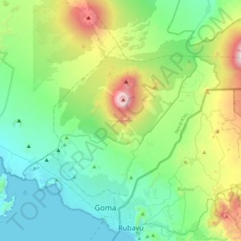
Name: Nyiragongo topographic map, elevation, terrain.
Location: Nyiragongo, North Kivu, Democratic Republic of the Congo (-1.65230 29.15043 -1.44755 29.47321)
Average elevation: 1,970 m
Minimum elevation: 1,456 m
Maximum elevation: 3,532 m
Make a donation
Gear up for your next adventure:
As an Amazon Associate, this site earns from qualifying purchases at no extra cost to you.
Other topographic maps
Click on a map to view its topography, its elevation and its terrain.
Nyiragongo
Democratic Republic of the Congo > North Kivu > Nyiragongo
Mount Nyiragongo (/ˌnɪərəˈɡɒŋɡoʊ, -ˈɡɔːŋ-/ neer-ə-GONG-go) is an active stratovolcano with an elevation of 3,470 m (11,385 ft) in the Virunga Mountains associated with the Albertine Rift. It is located inside Virunga National Park, in the Democratic Republic of the Congo, about 12 km (7.5 mi)…
Average elevation: 3,090 m
Nyiragongo
Democratic Republic of the Congo > North Kivu > Nyiragongo
Mount Nyiragongo is an active stratovolcano with an elevation of 3,470 m (11,380 ft) in the Virunga Mountains associated with the Albertine Rift. It is located inside Virunga National Park, in the Democratic Republic of the Congo, about 20 km (12 mi) north of the town of Goma and Lake Kivu and just west of the…
Average elevation: 3,090 m