
Thank you for supporting this site ❤️
Make a donation
Make a donation
Gear up for your next adventure:
As an Amazon Associate, this site earns from qualifying purchases at no extra cost to you.
Hirschwang topographic map
Click on the map to display elevation.
Thank you for supporting this site ❤️
Make a donation
Make a donation
Gear up for your next adventure:
As an Amazon Associate, this site earns from qualifying purchases at no extra cost to you.
About this map
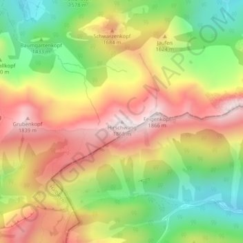
Name: Hirschwang topographic map, elevation, terrain.
Location: Hirschwang, Halblech, Landkreis Ostallgäu, Bayern, Deutschland (47.57871 10.88448 47.57881 10.88458)
Average elevation: 1,481 m
Minimum elevation: 1,102 m
Maximum elevation: 1,857 m
Thank you for supporting this site ❤️
Make a donation
Make a donation
Gear up for your next adventure:
As an Amazon Associate, this site earns from qualifying purchases at no extra cost to you.