
Make a donation
Gear up for your next adventure:
As an Amazon Associate, this site earns from qualifying purchases at no extra cost to you.
Denholm topographic map
Click on the map to display elevation.
Make a donation
Gear up for your next adventure:
As an Amazon Associate, this site earns from qualifying purchases at no extra cost to you.
Denholm
In Main Street, stands The Text House, a category B listed building, erected about 1910 by John Haddon (1845–1924), a medical doctor and author of published works on public sanitation and dietetics. The 3-storey house is in the arts and craft style. One of the texts on the front elevation is a reminder to take care with time before it passes, "TAK TENT IN TIME ~ ERE TIME BE TINT", the other text reminds the occupier that there were and will be others living in the house, "ALL WAS OTHERS ~ ALL WILL BE OTHERS".
Make a donation
Gear up for your next adventure:
As an Amazon Associate, this site earns from qualifying purchases at no extra cost to you.
About this map
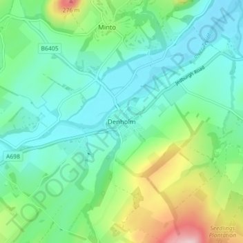
Name: Denholm topographic map, elevation, terrain.
Location: Denholm, Scottish Borders, Scotland, TD9 8NU, United Kingdom (55.43804 -2.70362 55.47804 -2.66362)
Average elevation: 128 m
Minimum elevation: 65 m
Maximum elevation: 307 m
Make a donation
Gear up for your next adventure:
As an Amazon Associate, this site earns from qualifying purchases at no extra cost to you.
Other topographic maps
Click on a map to view its topography, its elevation and its terrain.
Make a donation
Gear up for your next adventure:
As an Amazon Associate, this site earns from qualifying purchases at no extra cost to you.
Greenknowe Tower
United Kingdom > Scotland > Scottish Borders > Gordon > Nether Huntlywood
Average elevation: 157 m
Make a donation
Gear up for your next adventure:
As an Amazon Associate, this site earns from qualifying purchases at no extra cost to you.
Make a donation
Gear up for your next adventure:
As an Amazon Associate, this site earns from qualifying purchases at no extra cost to you.
Moffat Hills
United Kingdom > Scotland > Scottish Borders > Tweedsmuir
The Megget Stane (OS. Ref. NT152203) is by a cattle grid at the highest point between the Talla and Megget reservoirs on the minor road which runs from Tweedsmuir on the A701 to Cappercleuch by shore of St Mary's Loch. It is quite easy to miss the stone when coming from Talla as it is hidden by a gate. At an…
Average elevation: 430 m
Curling Pond
United Kingdom > Scotland > Scottish Borders > Earlston > Georgefield
Average elevation: 153 m
Hirsel Lake
United Kingdom > Scotland > Scottish Borders > Coldstream > The Hirsel
Average elevation: 37 m
Make a donation
Gear up for your next adventure:
As an Amazon Associate, this site earns from qualifying purchases at no extra cost to you.