
Make a donation
Gear up for your next adventure:
As an Amazon Associate, this site earns from qualifying purchases at no extra cost to you.
Arnstein topographic map
Click on the map to display elevation.
Make a donation
Gear up for your next adventure:
As an Amazon Associate, this site earns from qualifying purchases at no extra cost to you.
About this map
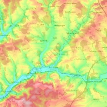
Name: Arnstein topographic map, elevation, terrain.
Location: Arnstein, Landkreis Main-Spessart, Bayern, 97450, Deutschland (49.93057 9.86463 50.05794 10.04609)
Average elevation: 282 m
Minimum elevation: 192 m
Maximum elevation: 385 m
Make a donation
Gear up for your next adventure:
As an Amazon Associate, this site earns from qualifying purchases at no extra cost to you.
Other topographic maps
Click on a map to view its topography, its elevation and its terrain.
Gut Ebenroth
Deutschland > Bayern > Landkreis Main-Spessart > Arnstein > Reuchelheim
Average elevation: 297 m
Make a donation
Gear up for your next adventure:
As an Amazon Associate, this site earns from qualifying purchases at no extra cost to you.
Neustadt a. Main
Deutschland > Bayern > Landkreis Main-Spessart > Neustadt a.Main
Average elevation: 299 m
Marktheidenfeld
Deutschland > Bayern > Landkreis Main-Spessart > Marktheidenfeld > Marktheidenfeld
Average elevation: 236 m
Make a donation
Gear up for your next adventure:
As an Amazon Associate, this site earns from qualifying purchases at no extra cost to you.
Brückenfundamentloch Reichsautobahn Strecke 46, Fulda-Würzburg
Deutschland > Bayern > Landkreis Main-Spessart > Gemünden am Main > Seifriedsburg
Average elevation: 307 m
Eichenfürst
Deutschland > Bayern > Landkreis Main-Spessart > Marktheidenfeld > Altfeld
Average elevation: 253 m
Make a donation
Gear up for your next adventure:
As an Amazon Associate, this site earns from qualifying purchases at no extra cost to you.
Hasberg
Deutschland > Bayern > Landkreis Main-Spessart > Ruppertshüttener Forst
Average elevation: 417 m
Make a donation
Gear up for your next adventure:
As an Amazon Associate, this site earns from qualifying purchases at no extra cost to you.
Make a donation
Gear up for your next adventure:
As an Amazon Associate, this site earns from qualifying purchases at no extra cost to you.
Bayerische Schanz (507,9)
Deutschland > Bayern > Landkreis Main-Spessart > Lohr am Main
Average elevation: 491 m
Make a donation
Gear up for your next adventure:
As an Amazon Associate, this site earns from qualifying purchases at no extra cost to you.
Rengersbrunn
Deutschland > Bayern > Landkreis Main-Spessart > Fellen > Rengersbrunn
Average elevation: 437 m
Make a donation
Gear up for your next adventure:
As an Amazon Associate, this site earns from qualifying purchases at no extra cost to you.
Arnstein
Deutschland > Bayern > Landkreis Main-Spessart > Arnstein > Arnstein
Average elevation: 279 m
Adelsberg
Deutschland > Bayern > Landkreis Main-Spessart > Gemünden am Main > Adelsberg
Average elevation: 246 m
Seifriedsburg
Deutschland > Bayern > Landkreis Main-Spessart > Gemünden am Main
Average elevation: 289 m
Make a donation
Gear up for your next adventure:
As an Amazon Associate, this site earns from qualifying purchases at no extra cost to you.
Langenprozelten
Deutschland > Bayern > Landkreis Main-Spessart > Gemünden am Main
Average elevation: 246 m
Make a donation
Gear up for your next adventure:
As an Amazon Associate, this site earns from qualifying purchases at no extra cost to you.