
Rigaud topographic map
Interactive map
Click on the map to display elevation.
About this map
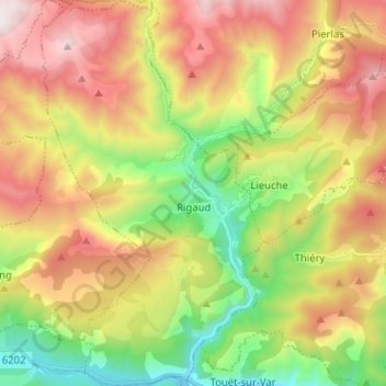
Name: Rigaud topographic map, elevation, terrain.
Average elevation: 1,073 m
Minimum elevation: 327 m
Maximum elevation: 1,956 m
Other topographic maps
Click on a map to view its topography, its elevation and its terrain.
Aspremont
Francia > Provenza-Alpes-Costa Azul > Alpes Marítimos > Aspremont
Aspremont, Niza, Alpes Marítimos, Provenza-Alpes-Costa Azul, Francia metropolitana, 06790, Francia
Average elevation: 367 m